

Art theme trail


- pets allowed
- All weather
- Suitable for families
- Suitable for kids (all ages)
- culturally interesting
- Flatly
Interactive elevation profile
Create PDF
Tour-Details
Starting place: 4853 Steinbach am Attersee
Destination: 4853 Steinbach am Attersee
duration: 0h 45m
length: 1,4 km
Lowest point: 469m
Highest point: 476m
difficulty: easy
condition: medium
panoramic view: Great panorama
Paths covering:
Hiking trail
powered by TOURDATA
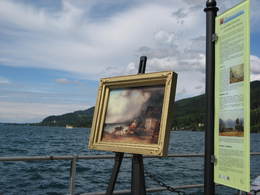
In and around Steinbach and Weißenbach many artists such as Friedrich Gulda, Charlotte Wolter, Gustav Klimt, Gustav Mahler, Hedwig Bleibtreu or Franz von Schönthan sought inspiration from the fascination that is the Lake Attersee and its surrounding landscapes.
Along this 2.5 km trail you will learn interesting details about these personalities on numerous information panels. Together with the accompanying audio guides this art theme trail turns into a musical walk through Weißenbach.Starting point: Gasthaus Pension zur Nixe
Time: about 45 minutes
Time with audio guide: about 2 – 2.5 hours
For more information and musical accompaniment you can download the free audio guide from Hearonymus (the guide is available in English and German).
You can get it here in the oogle Play Store or here in the Apple App Store.
Please search in the Hearonymus-App for the keyword Steinbach.
further information:
- Flatly
- Board possible
Details - hiking
- themed path
Parking
- Parking space: 5
General price information
Deposit for audio guides
- All weather
- Suitable for groups
- Suitable for schools
- Suitable for kids (all ages)
- Pets allowed
- Suitable for families
- Spring
- Summer
- Autumn
- Early winter
Please get in touch for more information.
4853 Steinbach am Attersee
Phone +43 7666 7719 - 60
E-Mail info.steinbach@attersee.at
Web attersee-attergau.salzkammergut.at
https://attersee-attergau.salzkammergut.at
You can also visit us on
Visit us on Facebook Visit our videochannel on YouTube WikipediaInteractive elevation profile
Create PDF
Tour-Details
Starting place: 4853 Steinbach am Attersee
Destination: 4853 Steinbach am Attersee
duration: 0h 45m
length: 1,4 km
Lowest point: 469m
Highest point: 476m
difficulty: easy
condition: medium
panoramic view: Great panorama
Paths covering:
Hiking trail
powered by TOURDATA