

Schoberstein (1.037m)


- pets allowed
Interactive elevation profile
Create PDF
Tour-Details
Starting place: 4853 Steinbach am Attersee
Destination: 4853 Steinbach am Attersee
duration: 2h 30m
length: 6,2 km
Altitude difference (uphill): 523m
Altitude difference (downhill): 523m
Lowest point: 481m
Highest point: 986m
difficulty: difficult
condition: difficult
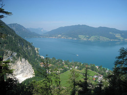
panoramic view: Great panorama
Paths covering:
Path / trail, Gravel, unfixed, Hiking trail
powered by TOURDATA
Trail AV 820
This short mountain tour leads to a popular summit in the Höllengebirge.
Get inspired now and try out the 360° perspectives tour!
Retreat:
Gasthaus "Zur Nixe" - Tel. +43 7663 610
Hotel Post - Tel. +43 7663 8141
Café Fürthauer - Tel. +43 7663 229
Parking
- Parking space: 30
There is a large parking lot on the avenue in Weißenbach next to the B152. There ist a fee from June to August: € 4.00 a day.
- Suitable for kids (6 - 14 Year)
- Pets allowed
- Suitable for single travelers
- Suitable for friends
- Suitable for couples
- Spring
- Summer
- Autumn
Please get in touch for more information.
Steinbach 5
4853 Steinbach am Attersee
Phone +43 7666 7719 - 60
E-Mail info.steinbach@attersee.at
Web attersee-attergau.salzkammergut.at
Web www.bergsteigerdoerfer.at/12-0-Berg…
https://attersee-attergau.salzkammergut.at
http://www.bergsteigerdoerfer.at/12-0-Bergsteigerdorf-Steinbach-am-Attersee.html
http://www.bergsteigerdoerfer.at/12-0-Bergsteigerdorf-Steinbach-am-Attersee.html
You can also visit us on
Visit us on Facebook Visit our videochannel on YouTube WikipediaInteractive elevation profile
Create PDF
Tour-Details
Starting place: 4853 Steinbach am Attersee
Destination: 4853 Steinbach am Attersee
duration: 2h 30m
length: 6,2 km
Altitude difference (uphill): 523m
Altitude difference (downhill): 523m
Lowest point: 481m
Highest point: 986m
difficulty: difficult
condition: difficult
panoramic view: Great panorama
Paths covering:
Path / trail, Gravel, unfixed, Hiking trail
powered by TOURDATA