

Pankrazius-Wanderung


- Suitable for families
- Flatly
Interactive elevation profile
Create PDF
Tour-Details
Path number: 14 - Wanderweg
Starting place: 4725 St. Aegidi
Destination: 4725 St. Aegidi
duration: 2h 19m
length: 8,8 km
Altitude difference (uphill): 95m
Altitude difference (downhill): 106m
Lowest point: 488m
Highest point: 595m
difficulty: medium
condition: medium
panoramic view: Some Views
Paths covering:
Asphalt, Hiking trail
powered by TOURDATA
This hiking trail has the trail number 14.
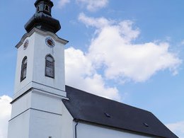
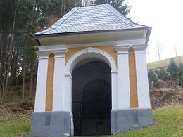
The starting point of the hiking route is the parish church of St. Aegidi with its beautifully landscaped war memorial. From the village centre, the hike leads in a south-easterly direction, initially on pavements and footpaths past the schools and a protected lime tree, to Lehen. Once there, turn right after the blocks of flats onto Güterweg Lehen. At a fork in the road, take the left-hand road, which turns into a dirt track. Downhill and uphill past Grübl, follow Roßgattern-Straße on the right to Gasthaus Auinger in Fraunhof. Opposite the inn, a path leads through the forest to Mittelbach, where it winds its way past meadows and fields to reach the romantic foothills of the Kößlbachtal nature reserve.The ruins of Burgstall, whose masses of stone have towered over the Kößlbachtal valley for more than 800 years, await you, as does the Pankraz Chapel, where healing water flows from a spring - a place that conveys complete peace and tranquillity.
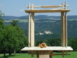
Follow the Mittelbach goods road via Maierhof, Mittelbach and Tullern in the direction of St. Aegidi. You reach the Burgblick on the panoramic road. After a relaxing break under fruit trees with a view of Rannariedl Castle in the Mühlviertel, the trail leads back to the starting point.
- Suitable for groups
- Suitable for schools
- Suitable for kids (6 - 10 Year)
- Suitable for single travelers
- Suitable for families
- Suitable for friends
- Suitable for couples
- Suitable for children
- Spring
- Summer
- Autumn
Please get in touch for more information.
St. Aegidi 10
4725 St. Aegidi
Phone +43 7717 7355 - 0
Fax machine +43 7717 7355 - 4
E-Mail gemeinde@st-aegidi.ooe.gv.at
Web www.st-aegidi.at
http://www.st-aegidi.at
Interactive elevation profile
Create PDF
Tour-Details
Path number: 14 - Wanderweg
Starting place: 4725 St. Aegidi
Destination: 4725 St. Aegidi
duration: 2h 19m
length: 8,8 km
Altitude difference (uphill): 95m
Altitude difference (downhill): 106m
Lowest point: 488m
Highest point: 595m
difficulty: medium
condition: medium
panoramic view: Some Views
Paths covering:
Asphalt, Hiking trail
powered by TOURDATA