

water trail


- All weather
- Suitable for families
Interactive elevation profile
Create PDF
Tour-Details
Path number: 11
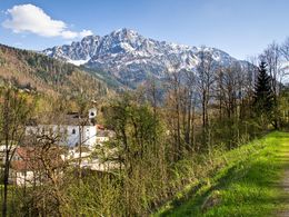
Starting place: 4582 Spital am Pyhrn
Destination: 4582 Spital am Pyhrn
duration: 1h 33m
length: 5,1 km
Altitude difference (uphill): 194m
Altitude difference (downhill): 15m
Lowest point: 640m
Highest point: 826m
difficulty: very easy
condition: very easy
panoramic view: Some Views
Paths covering:
Other
powered by TOURDATA
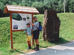
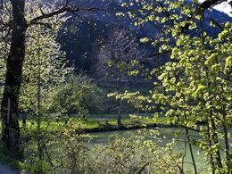
The water course leads you along the Pyhrnbach stream and along the Teilbach stream. Along the way, you will also get to know the Pfleger pond, the valley station of the Wurzeralm funicular railway.
What you always wanted to know: how long does a toad need to cross the B138? What is the favorite dish of trout? How do caves form in the limestone?
The answers to these and many more questions can be found along the nature trail. Find out about which tiny animals live in the Teichl and the Pyhrnbach and how the water quality can be determined. Solve the puzzle and get acquainted with some trees. You will also learn why woody shrubs on the bank are important for a body of water and how the Spitaler forests are influenced. Take a journey back in time to the Ice Age, when the landscape around Spital am Pyhrn has been transformed. And get to know the nursing pond, which is visited annually by several thousand toads and frogs as spawning waters. A detour to the second origin of the Teichl (the origin is on the Wurzeralm)
The nature trail accompanies the Teichl and the Pyhrnbach through the valley. However, the Teichl rises high up in the area of the Brunnsteinersee and meanders through the bog area of the Teichlboden, where it suddenly disappears into the ground and re-emerges in the valley.
Starting point: Parking lot - Sparkasse Spital am Pyhrn
Destination: Wurzeralm funicular valley station
Details - hiking
- themed path
- educational path
Accessibility / arrival
From the A9 motorway take the Spital am Pyhrn exit and turn left towards the center. After about 2 kilometers to the left is the parking lot at the Sparkasse.
- All weather
- Suitable for groups
- Suitable for schools
- Suitable for teenagers
- Suitable for seniors
- Suitable for single travelers
- Suitable for families
- Suitable for friends
- Suitable for couples
- Suitable for children
- Spring
- Summer
- Autumn
- Early winter
Please get in touch for more information.

Stiftsplatz 1
4582 Spital am Pyhrn
Phone +43 7563 249
Fax machine +43 7563 249 - 20
E-Mail spital@pyhrn-priel.net
Web www.urlaubsregion-pyhrn-priel.at
https://www.urlaubsregion-pyhrn-priel.at
")
")
")

Interactive elevation profile
Create PDF
Tour-Details
Path number: 11
Starting place: 4582 Spital am Pyhrn
Destination: 4582 Spital am Pyhrn
duration: 1h 33m
length: 5,1 km
Altitude difference (uphill): 194m
Altitude difference (downhill): 15m
Lowest point: 640m
Highest point: 826m
difficulty: very easy
condition: very easy
panoramic view: Some Views
Paths covering:
Other
powered by TOURDATA