

Wurzeralm high-altitude cross-country trail - S5


Interactive elevation profile
Create PDF
Tour-Details
Path number: S5
Starting place: 4582 Spital am Pyhrn
Destination: 4582 Spital am Pyhrn
duration: 1h 20m
length: 4,7 km
Altitude difference (uphill): 101m
Altitude difference (downhill): 86m
Lowest point: 1.358m
Highest point: 1.421m
difficulty: easy
condition: easy
panoramic view: Great panorama
Paths covering:
snow
powered by TOURDATA
Trail not in operation
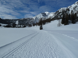
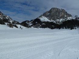
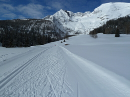
The Wurzeralm high-altitude cross-country trail is a sunny trail with guaranteed snow for all the family to enjoy.
The trail takes skiers across the high and low marshland of Teichlboden, and enjoys a spectacular backdrop at the foot of the Warscheneck mountain. Starting point: Wurzeralm mountain station
further information:
- Board possible
Details - Trail
- Nordic skiing facilities: Marked Nordic skiing run
- Type of Nordic skiing run: Classic + skating
- free
When the Wurzeralm funicular railway is in operation, and when the snow conditions are right!
Accessibility / arrival
You can only reach the entry point for the trail by taking the Wurzeralm funicular railway from Spital am Pyhrn. It takes approximately 15 minutes to travel on foot from the mountain station of the funicular railway to the entry point for the trail at Linzerhaus lodge.
General price information
There is no charge for using the trail!
However, you require a return ticket for the Wurzeralm funicular railway!
Most economical season
- Early winter
- Deep winter
Please get in touch for more information.

Hinterstoder 21
4582 Spital am Pyhrn
Phone +43 7564 5275
Fax machine +43 7564 5275 - 130
E-Mail info@hiwu.at
Web www.urlaubsregion-pyhrn-priel.at
Web skisport.com/de/hiwu
https://www.urlaubsregion-pyhrn-priel.at
https://skisport.com/de/hiwu
https://skisport.com/de/hiwu

")
Interactive elevation profile
Create PDF
Tour-Details
Path number: S5
Starting place: 4582 Spital am Pyhrn
Destination: 4582 Spital am Pyhrn
duration: 1h 20m
length: 4,7 km
Altitude difference (uphill): 101m
Altitude difference (downhill): 86m
Lowest point: 1.358m
Highest point: 1.421m
difficulty: easy
condition: easy
panoramic view: Great panorama
Paths covering:
snow
powered by TOURDATA