

Radroute Kramesau - Schlögen


- pets allowed
- All weather
- Suitable for kids (all ages)
- Flatly
- Possible accommodation
Interactive elevation profile
Create PDF
Tour-Details
Starting place: 4143 Neustift im Mühlkreis
Destination: 4143 Neustift im Mühlkreis
duration: 4h 46m
length: 45,7 km
Altitude difference (uphill): 648m
Altitude difference (downhill): 679m
Lowest point: 276m
Highest point: 606m
difficulty: easy
condition: easy
panoramic view: Great panorama
Paths covering:
Asphalt
powered by TOURDATA
Cycle route Kramesau - Schlögen
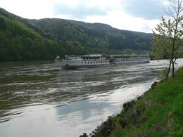
We start at Gasthaus Luger in Kramesau and cycle along the Danube cycle path (formerly the Treppelweg) down the Danube. After 1.5 km, the Treppelweg joins a country road. We follow this to the right to Niederranna. The cycle path leads us through the village, under the Danube bridge, past the "Freizeller Schlössl" (on the hill we can see the ruins of Haichenbach) to the famous Schlögener Donauschlinge.Once there, you have the option of crossing the Schlögener Schlinge with the longitudinal ferry or crossing the Danube with the Au-Schlögen transverse ferry.
If you want to return on the other side of the Danube, you can cycle upstream on the main road to the Danube bridge at Niederranna and on to Kramesau.
- All weather
- Suitable for groups
- Suitable for schools
- Suitable for kids (all ages)
- Pets allowed
- Summer
Please get in touch for more information.
4143 Neustift im Mühlkreis
Phone +43 7284 8155
E-Mail info@familienurlaub-neustift.at
Web www.familienurlaub-neustift.at
http://www.familienurlaub-neustift.at
You can also visit us on
Visit us on FacebookInteractive elevation profile
Create PDF
Tour-Details
Starting place: 4143 Neustift im Mühlkreis
Destination: 4143 Neustift im Mühlkreis
duration: 4h 46m
length: 45,7 km
Altitude difference (uphill): 648m
Altitude difference (downhill): 679m
Lowest point: 276m
Highest point: 606m
difficulty: easy
condition: easy
panoramic view: Great panorama
Paths covering:
Asphalt
powered by TOURDATA