

Kaltenbachwildnis in Gmunden


- All weather
- Suitable for families
Interactive elevation profile
Create PDF
Tour-Details
Starting place: 4810 Gmunden
Destination: 4810 Gmunden
duration: 0h 51m
length: 2,2 km
Altitude difference (uphill): 131m
Altitude difference (downhill): 130m
Lowest point: 443m
Highest point: 546m
difficulty: easy
condition: easy
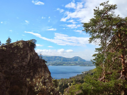
panoramic view: Great panorama
Paths covering:
Hiking trail
powered by TOURDATA
The Kaltenbach-Wildnis is situated submontane the Traunstein on the eastern bank of the lake Traunsee.
Starting points are the Seegasthof Ramsau and the Seegasthof Hois'n in Gmunden. The Kaltenbachwildnis is an impressive hiking tour with beautiful panoramic view. Starting point: Seegasthof Raumsau and Seegasthof Hois'n
Destination: Kaltenbachwildnis
Accessibility / arrival
from the highway:departure Regau-B 145 in the direction of Bad Ischl-trough the center of Gmunden-across the bridge Traunbrücke-turn right in the direction of the cable car "Grünbergseilbahn"-alsway straight ahaid till the Seegasthof Ramsau or Seegasthof Hois'n
- All weather
- Suitable for single travelers
- Suitable for families
- Suitable for friends
- Suitable for couples
- Suitable for children
- Spring
- Summer
- Autumn
- Early winter
Please get in touch for more information.
Toscanapark 1
4810 Gmunden
Phone +43 7612 74451
E-Mail info@traunsee-almtal.at
Web www.traunsee-almtal.at
http://www.traunsee-almtal.at
Interactive elevation profile
Create PDF
Tour-Details
Starting place: 4810 Gmunden
Destination: 4810 Gmunden
duration: 0h 51m
length: 2,2 km
Altitude difference (uphill): 131m
Altitude difference (downhill): 130m
Lowest point: 443m
Highest point: 546m
difficulty: easy
condition: easy
panoramic view: Great panorama
Paths covering:
Hiking trail
powered by TOURDATA