

Warscheneck via Wurzeralm and Rote Wand


Interactive elevation profile
Create PDF
Tour-Details
Path number: 201
Starting place: 4582 Spital am Pyhrn
Destination: 4582 Spital am Pyhrn
duration: 4h 30m
length: 6,5 km
Altitude difference (uphill): 1.074m
Altitude difference (downhill): 124m
Lowest point: 1.363m
Highest point: 2.360m
difficulty: difficult
condition: difficult
panoramic view: Great panorama
Paths covering:
Hiking trail
powered by TOURDATA
Hike from the Wurzeralm via the Brunnsteinersee to the Rote Wand, Toter Mann and on to the Warscheneck.
From the mountain station of the Wurzeralm mountain station, hike to the Brunnsteinersee, until which point you are on a gravel road. From the Brunnsteinersee, there begins a steep, though harmless climb to the Rote Wand saddle.Continue by hiking up along the ridgeline, across the Speikwiese to the shoulder. Now comes a short hike down to where the Toter Mann begins to rise (surefootedness a must).
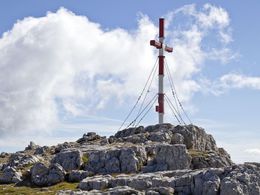
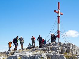
From the Toter Mann, a gently ascending rocky plateau leads up to the summit of the Warscheneck.
Trekking trail No. 201 drops down to the Zellerhütte and continues to Vorder- and Hinterstoder.
Starting point: The Wurzeralm funicular mountain station
Destination: Summit of the Warscheneck
further information:
- Board possible


")
")
")

")
")
")
Accessibility / arrival
Parking Wurzeralm funicular valley station and ride up the funicular.
Most economical season
- Spring
- Summer
- Autumn
Please get in touch for more information.

Stiftsplatz 1
4582 Spital am Pyhrn
Phone +43 7563 249
Fax machine +43 7563 249 - 20
E-Mail spital@pyhrn-priel.net
Web www.urlaubsregion-pyhrn-priel.at/
https://www.urlaubsregion-pyhrn-priel.at/
Interactive elevation profile
Create PDF
Tour-Details
Path number: 201
Starting place: 4582 Spital am Pyhrn
Destination: 4582 Spital am Pyhrn
duration: 4h 30m
length: 6,5 km
Altitude difference (uphill): 1.074m
Altitude difference (downhill): 124m
Lowest point: 1.363m
Highest point: 2.360m
difficulty: difficult
condition: difficult
panoramic view: Great panorama
Paths covering:
Hiking trail
powered by TOURDATA