

Toter Mann – from the Wurzeralm


Interactive elevation profile
Create PDF
Tour-Details
Path number: 201
Starting place: 4582 Spital am Pyhrn
Destination: 4582 Spital am Pyhrn
duration: 4h 4m
length: 5,8 km
Altitude difference (uphill): 971m
Altitude difference (downhill): 113m
Lowest point: 1.363m
Highest point: 2.275m
difficulty: medium
condition: medium
panoramic view: Great panorama
Paths covering:
Gravel, Hiking trail
powered by TOURDATA
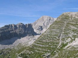
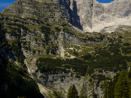
From the mountain station of the Wurzeralm funicular, the hike leads via Brunnsteiner See to the Rote Wand alpine saddle, then continues to the summit of the Toter Mann.
Hike from the mountain station of the Wurzeralm down a gravel road which drops gradually to the Brunnsteinersee.Now on a marked trail to the Rote Wand saddle, which rises steeply through a series of switchbacks. Hike past the Italienerloch until, on the south-east ridgeline, the hiking path from the Dümlerhütte feeds into our trail. Continue your steep ascent on a trail that is now rather slippery, coming to the high plateau of the Speikwiese. Briefly continue following the path towards Warscheneck, but you will soon leave it heading south to the Toter Mann (elev. 2137m).
Starting point: Wurzeralm funicular mountain station
Destination: Summit of the Toter Mann
further information:
- Board possible


")
")

")
")
")

Accessibility / arrival
Car park for the Wurzeralm funicular valley station, then ride up on the funicular.
Most economical season
- Spring
- Summer
- Autumn
Please get in touch for more information.

Stiftsplatz 7
4582 Spital am Pyhrn
Phone +43 7563 249 - 99
Fax machine +43 7563 249 - 20
E-Mail spital@pyhrn-priel.net
Web www.urlaubsregion-pyhrn-priel.at/
https://www.urlaubsregion-pyhrn-priel.at/
Interactive elevation profile
Create PDF
Tour-Details
Path number: 201
Starting place: 4582 Spital am Pyhrn
Destination: 4582 Spital am Pyhrn
duration: 4h 4m
length: 5,8 km
Altitude difference (uphill): 971m
Altitude difference (downhill): 113m
Lowest point: 1.363m
Highest point: 2.275m
difficulty: medium
condition: medium
panoramic view: Great panorama
Paths covering:
Gravel, Hiking trail
powered by TOURDATA