

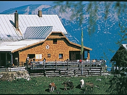
Trails to the Dümlerhütte


- Possible accommodation
Interactive elevation profile
Create PDF
Tour-Details
Path number: 293, 218
Starting place: 4575 Roßleithen
Destination: 4575 Roßleithen
duration: 3h 14m
length: 4,9 km
Altitude difference (uphill): 794m
Altitude difference (downhill): 9m
Lowest point: 666m
Highest point: 1.458m
difficulty: medium
condition: medium
panoramic view: Great panorama
Paths covering:
Hiking trail
powered by TOURDATA
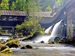
From the tavern Gasthaus Sengsschmied in Roßleithen walk through the scythe factory to the bottom station of the material cable car (luggage transport).
Cross the stream and continue to the pasture Roßleithner-Reith and via the Tommerl-Alm pasture to the Dümlerhütte alpine hut.Trail-Nr: 293, 218
Starting point: Parking below Gasthaus Sengsschmied in Roßleithen
Destination: Dümlerhütte (alpine hut) in Roßleithen
further information:
- Possible accommodation
- Board possible
")
Accessibility / arrival
Parking next Fux engineering in Roßleithen
Most economical season
- Spring
- Summer
- Autumn
Please get in touch for more information.

4575 Roßleithen
Phone +43 7562 5266
Fax machine +43 7562 5266 - 10
E-Mail info@pyhrn-priel.net
Web www.urlaubsregion-pyhrn-priel.at/
https://www.urlaubsregion-pyhrn-priel.at/
Interactive elevation profile
Create PDF
Tour-Details
Path number: 293, 218
Starting place: 4575 Roßleithen
Destination: 4575 Roßleithen
duration: 3h 14m
length: 4,9 km
Altitude difference (uphill): 794m
Altitude difference (downhill): 9m
Lowest point: 666m
Highest point: 1.458m
difficulty: medium
condition: medium
panoramic view: Great panorama
Paths covering:
Hiking trail
powered by TOURDATA