

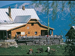
Trails to the Dümlerhütte


- Possible accommodation
Interactive elevation profile
Create PDF
Tour-Details
Path number: 299
Starting place: 4582 Spital am Pyhrn
Destination: 4575 Roßleithen
duration: 2h 52m
length: 3,6 km
Altitude difference (uphill): 712m
Altitude difference (downhill): 59m
Lowest point: 806m
Highest point: 1.459m
difficulty: medium
condition: medium
panoramic view: Individual Views
Paths covering:
Gravel, Hiking trail
powered by TOURDATA
From the parking area pass the tavern Gasthaus Seebauer in Roßleithen.
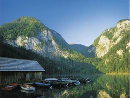
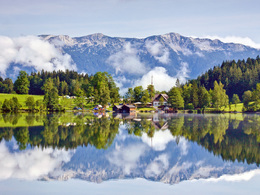
Walk along the western banks of lake Gleinkersee and continue through to the Zick-Alm pasture and from there to your right to the Dümlerhütte alpine hut.Trail-Nr: 299
Starting point: Parking at Lake Gleinkersee in Spital am Phyrn
Destination: Dümlerhütte in Roßleithen
further information:
- Possible accommodation
- Board possible
")
")


Accessibility / arrival
Parking at Gleinkersee
Most economical season
- Spring
- Summer
- Autumn
Please get in touch for more information.

Bahnhofstraße 2
4575 Roßleithen
Phone +43 7562 5266
Fax machine +43 7562 5266 - 10
E-Mail info@pyhrn-priel.net
Web www.urlaubsregion-pyhrn-priel.at
https://www.urlaubsregion-pyhrn-priel.at
Interactive elevation profile
Create PDF
Tour-Details
Path number: 299
Starting place: 4582 Spital am Pyhrn
Destination: 4575 Roßleithen
duration: 2h 52m
length: 3,6 km
Altitude difference (uphill): 712m
Altitude difference (downhill): 59m
Lowest point: 806m
Highest point: 1.459m
difficulty: medium
condition: medium
panoramic view: Individual Views
Paths covering:
Gravel, Hiking trail
powered by TOURDATA