

Seespitz from Gleinkersee on the Michael-Kniewasser-Steig


- Suitable for families
Interactive elevation profile
Create PDF
Tour-Details
Path number: 292
Starting place: 4582 Spital am Pyhrn
Destination: 4582 Spital am Pyhrn
duration: 4h 0m
length: 8,5 km
Altitude difference (uphill): 776m
Altitude difference (downhill): 770m
Lowest point: 805m
Highest point: 1.563m
difficulty: medium
condition: medium
panoramic view: Individual Views
Paths covering:
Gravel, Hiking trail
powered by TOURDATA
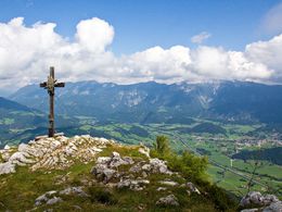
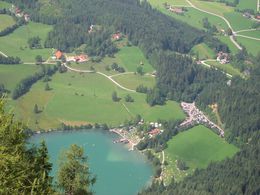
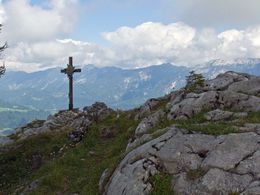
Above the natural gem Gleinkersee is the Seespitz Mountain. And exactly from Gleinkersee you hike to the Seespitz about the Michael-Kniewasser-Steig.
At a fork in the hiking trail, continue left along the Michael-Kniewasser-Steig trail with hiking trail number 292 to Seespitz with a great panorama and a direct view of Lake Gleinkersee.
Follow the same route on the return journey.
Starting point: Parking by the Gleinkersee in Spital am Pyhrn
Destination: Parking by the Gleinkersee in Spital am Pyhrn
further information:
- Board possible

Accessibility / arrival
Parking by the Gleinkersee
- Charging point for e-bikes (free of charge)
- Suitable for groups
- Suitable for kids (10 - 14 Year)
- Suitable for teenagers
- Suitable for seniors
- Suitable for single travelers
- Suitable for families
- Suitable for friends
- Suitable for couples
- Suitable for children
- Spring
- Summer
- Autumn
Please get in touch for more information.

Stiftsplatz 1
4582 Spital am Pyhrn
Phone +43 7563 249
Fax machine +43 7563 249 - 20
E-Mail spital@pyhrn-priel.net
Web www.urlaubsregion-pyhrn-priel.at/
https://www.urlaubsregion-pyhrn-priel.at/
")
")
")
")
")
")
Interactive elevation profile
Create PDF
Tour-Details
Path number: 292
Starting place: 4582 Spital am Pyhrn
Destination: 4582 Spital am Pyhrn
duration: 4h 0m
length: 8,5 km
Altitude difference (uphill): 776m
Altitude difference (downhill): 770m
Lowest point: 805m
Highest point: 1.563m
difficulty: medium
condition: medium
panoramic view: Individual Views
Paths covering:
Gravel, Hiking trail
powered by TOURDATA