

Kalkalpen Trail stage 6


- Possible accommodation
Interactive elevation profile
Create PDF
Tour-Details
Path number: 617, 618, 601
Starting place: 4582 Spital am Pyhrn
Destination: 4582 Spital am Pyhrn
duration: 5h 6m
length: 13,3 km
Altitude difference (uphill): 576m
Altitude difference (downhill): 1.283m
Lowest point: 640m
Highest point: 1.423m
difficulty: medium
condition: medium
panoramic view: Great panorama
Paths covering:
Gravel, Hiking trail
powered by TOURDATA
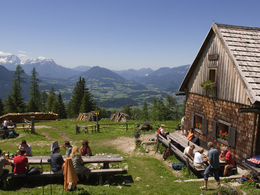
Gowilalm Pasture - Spital am Pyhrn
Theme: Pastures – Water Gorges
Starting point: Gowilalm hut in Spital am Pyhrn
Destination: Center at the parking lot at the Sparkasse
further information:
- Possible accommodation
- Board possible
Details - hiking
- themed path
")

")
")
")

Accessibility / arrival
Gowilalm hut in Spital am Phyrn
Most economical season
- Spring
- Summer
- Autumn
Please get in touch for more information.

Stiftsplatz 1
4582 Spital am Pyhrn
Phone +43 7563 249
Fax machine +43 7563 249 - 20
E-Mail spital@pyhrn-priel.net
Web www.oberoesterreich.at/oesterreich-…
Web www.urlaubsregion-pyhrn-priel.at
https://www.oberoesterreich.at/oesterreich-tour/detail/430001734/kalkalpenweg-nationalpark-kalkalpen.html
https://www.urlaubsregion-pyhrn-priel.at
https://www.urlaubsregion-pyhrn-priel.at
Interactive elevation profile
Create PDF
Tour-Details
Path number: 617, 618, 601
Starting place: 4582 Spital am Pyhrn
Destination: 4582 Spital am Pyhrn
duration: 5h 6m
length: 13,3 km
Altitude difference (uphill): 576m
Altitude difference (downhill): 1.283m
Lowest point: 640m
Highest point: 1.423m
difficulty: medium
condition: medium
panoramic view: Great panorama
Paths covering:
Gravel, Hiking trail
powered by TOURDATA