

Kalkalpen Trail stage 5


Interactive elevation profile
Create PDF
Tour-Details
Path number: 10,30,616
Starting place: 4580 Windischgarsten
Destination: 4582 Spital am Pyhrn
duration: 4h 0m
length: 11,5 km
Altitude difference (uphill): 730m
Lowest point: 609m
Highest point: 1.356m
difficulty: medium
condition: medium
panoramic view: Great panorama
Paths covering:
Asphalt, Hiking trail
powered by TOURDATA
Windischgarsten – Gowilalm Pasture
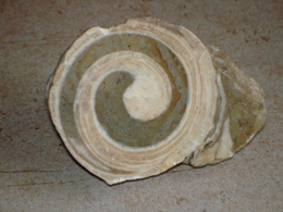
Theme: Geology
From the Windischgarsten market square, we walk a short distance eastwards to the fork in the road at Rosenau am Hengstpass or Spital am Pyhrn (Hödl hairdressing salon). At the "Proviantweg" signpost, we follow Pfarrgasse uphill past the parish hall to another fork in the road. The gravel path leads us along the edge of the slope above the Heimathaus (museum) and the outdoor pool into the landscape park (geological nature trail or geological features of this region by Oberschulrat Stanzel).
Now we take the well-maintained hiking trail near the stream into the valley (Millionenweg = millions of years of geological history) to the Pistlmühle sawmill. Here we walk upstream through the factory premises to the Schaffelmühle inn. We now walk to the right (Güterweg Bischofsberg) up the dust-free road, past Café Sophie to the fork in the road (to the right would be Hotel Sperlhof). After taking the left branch of the road, we walk eastwards along the dust-free goods road to the Hansl am Graben farmstead. We walk southwards uphill through the farmyard to the signpost and downhill to the left into the watery valley floor of the Fraitgraben. Here we take the forest path near the stream into the valley to the Ramitscheder mill. Further up the stream we reach the Stanglmühle house (former Lodenstampfe) and the road up to the Dansbach chapel.
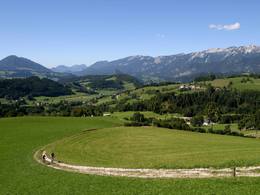
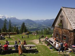
We follow the dust-free road up to the settlement area (fork in the road to Spital am Pyhrn to Gasthof Schrofler or Landhotel Oberwengerhof). Here we turn left a little eastwards to the next fork in the road and right uphill to the Singerskogel snack station. The road now leads us uphill a little, then right (car park) on trail no. 616. Partly on an alpine path, partly on a small road, crossing some forest paths, we finally hike up steeper to the Gowilalmhütte with a magnificent view of the wide Garstnertal valley and the surrounding mountains.
Starting point: Tourist Office Windischgarsten
Destination: Gowilalm hut in Spital am Phyrn
further information:
- Board possible
Details - hiking
- themed path

Accessibility / arrival
by car:
Drive from the highway 138 in Windischgarsten north or center towards the center. At the company E-TECH you come to a narrow point, you pass this and then directly left is the tourist office Windischgarsten.
Most economical season
- Summer
Please get in touch for more information.

Bahnhofstraße 2
4580 Windischgarsten
Phone +43 7562 5266
Fax machine +43 7562 5266 - 10
E-Mail info@pyhrn-priel.net
Web www.oberoesterreich.at/oesterreich-…
Web www.urlaubsregion-pyhrn-priel.at
https://www.oberoesterreich.at/oesterreich-tour/detail/430001734/kalkalpenweg-nationalpark-kalkalpen.html
https://www.urlaubsregion-pyhrn-priel.at
https://www.urlaubsregion-pyhrn-priel.at
Interactive elevation profile
Create PDF
Tour-Details
Path number: 10,30,616
Starting place: 4580 Windischgarsten
Destination: 4582 Spital am Pyhrn
duration: 4h 0m
length: 11,5 km
Altitude difference (uphill): 730m
Lowest point: 609m
Highest point: 1.356m
difficulty: medium
condition: medium
panoramic view: Great panorama
Paths covering:
Asphalt, Hiking trail
powered by TOURDATA