

Kalkalpen Trail stage 10


- Possible accommodation
Interactive elevation profile
Create PDF
Tour-Details
Starting place: 4573 Hinterstoder
Destination: 4573 Hinterstoder
duration: 5h 23m
length: 15,6 km
Altitude difference (uphill): 526m
Altitude difference (downhill): 1.298m
Lowest point: 584m
Highest point: 1.511m
difficulty: medium
condition: medium
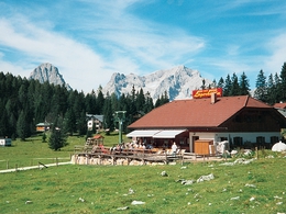
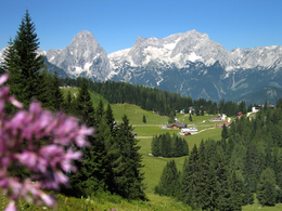
panoramic view: Great panorama
Paths covering:
Asphalt, Hiking trail
powered by TOURDATA
Edtbauernalm pasture - Hinterstoder
Theme: Alpinism
Starting point: Hutterer Böden Hinterstoder
Destination: Center - tourist office in Hinterstoder
further information:
- Possible accommodation
- Board possible
Details - hiking
- themed path

Accessibility / arrival
by car:
From Vorderstoder follow the signs Hinterstoder - At the crossroads turn left to Hinterstoder - valley station cable car
by train:
A9 motorway - exit St. Pankraz - then turn left - at GH Steyrbrücke left to Hinterstoder - valley station cable car
Most economical season
- Summer
Please get in touch for more information.
Hinterstoder 38
4573 Hinterstoder
Phone +43 7564 5263
Fax machine +43 7564 5263 - 30
E-Mail hinterstoder@pyhrn-priel.net
Web www.oberoesterreich.at/oesterreich-…
Web www.urlaubsregion-pyhrn-priel.at
https://www.oberoesterreich.at/oesterreich-tour/detail/430001734/kalkalpenweg-nationalpark-kalkalpen.html
https://www.urlaubsregion-pyhrn-priel.at
https://www.urlaubsregion-pyhrn-priel.at
Interactive elevation profile
Create PDF
Tour-Details
Starting place: 4573 Hinterstoder
Destination: 4573 Hinterstoder
duration: 5h 23m
length: 15,6 km
Altitude difference (uphill): 526m
Altitude difference (downhill): 1.298m
Lowest point: 584m
Highest point: 1.511m
difficulty: medium
condition: medium
panoramic view: Great panorama
Paths covering:
Asphalt, Hiking trail
powered by TOURDATA