

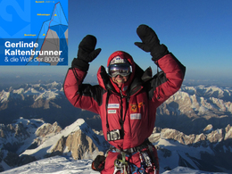
Trail "Between Heaven and Earth - Gerlinde Kaltenbrunner and the world of 8000"


- pets allowed
- Suitable for families
- culinary interesting
- Possible accommodation
Interactive elevation profile
Create PDF
Tour-Details
Path number: 430003159
Starting place: 4582 Spital am Pyhrn
Destination: 4582 Spital am Pyhrn
duration: 6h 30m
length: 9,7 km
Altitude difference (uphill): 1.597m
Altitude difference (downhill): 22m
Lowest point: 640m
Highest point: 2.216m
difficulty: medium
condition: medium
panoramic view: Dreamtour
Paths covering:
Asphalt, Climbing mount, Gravel, Hiking trail
powered by TOURDATA
After visiting the Museum "Between Heaven and Earth - Gerlinde Kaltenbrunner and the world of 8000" to start with the app from Spital am Pyhrn by Dr. Vogelgesang Klamm to Bosruckhütte, Rohrauerhaus on the big Pyhrgas.
The trail passes through the longest walk gorge of Upper Austria - the Dr. Vogelgesang Gorge - the "base camp" Bosruckhütte and from there to the "high camp" Rohrauerhaus. The hiking app performs good climbers to the summit of the Great Pyhrgas (2244 m).
further information:
- culinary interesting
- Possible accommodation
- Experience of nature
- Board possible
Details - hiking
- themed path


Accessibility / arrival
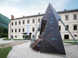
Drive in the center of Spital am Pyhrn. At the Sparkasse turn and use the car park. You are where the exhibition is located directly in front of it and the starting point for the walk in front of the monastery building!
- Parking space: 50
- Bus parking space: 5
- Suitable for groups
- Pets allowed
- Suitable for teenagers
- Suitable for single travelers
- Suitable for families
- Suitable for friends
- Suitable for couples
- Spring
- Summer
- Autumn
Not suitable for wheelchairs. The property is not compliant with Austria's ÖNORM legal standard.

Stiftsplatz 1
4582 Spital am Pyhrn
Phone +43 7563 249
Fax machine +43 7563 249 - 20
E-Mail info@weltder8000er.at
Web www.urlaubsregion-pyhrn-priel.at/oe…
https://www.urlaubsregion-pyhrn-priel.at/oesterreich-poi/detail/430016421/zwischen-himmel-und-erde-gerlinde-kaltenbrunner-und-die-welt-der-8000er.html?h=8451
")
")
")
Interactive elevation profile
Create PDF
Tour-Details
Path number: 430003159
Starting place: 4582 Spital am Pyhrn
Destination: 4582 Spital am Pyhrn
duration: 6h 30m
length: 9,7 km
Altitude difference (uphill): 1.597m
Altitude difference (downhill): 22m
Lowest point: 640m
Highest point: 2.216m
difficulty: medium
condition: medium
panoramic view: Dreamtour
Paths covering:
Asphalt, Climbing mount, Gravel, Hiking trail
powered by TOURDATA