

Schörfling-Hongar-Radtour


- All weather
- Flatly
Interactive elevation profile
Create PDF
Tour-Details
Starting place: 4861 Schörfling am Attersee
Destination: 4861 Schörfling am Attersee
duration: 2h 33m
length: 27,5 km
Altitude difference (uphill): 847m
Altitude difference (downhill): 843m
Lowest point: 469m
Highest point: 866m
difficulty: medium
condition: medium
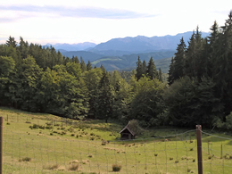
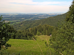
panoramic view: Some Views
Paths covering:
Asphalt, Gravel, Street, Other
powered by TOURDATA
At the train station in Kammer, Schörfling am Attersee the bike path starts and from there it continues towards Weyregg and to Aurach am Attersee. The bike tour is ideal for sporty cyclists and offers, among other things, a wide range of gastronomy.
- Start at Kammer-Schörfling train station in the left, direction to Weyregg.
- After 50m turn left again into the center of Schörfling. Follow the signage cycle path "R2".
- After 800m we reach the town hall. From there, follow the R2 cycling path towards Aurach.
- Km 1.6, we cross the federal road and continue on the left along the cycle route R2 towards Aurach.
- At km7 in the village Aurach turn right direction to Kasten-Hongar. Follow the road to the Almgasthof Schwarz.
- Km 11,1 we turn left to the Almgasthof Schwarz.
- After 12.4km we reach the Almgasthof. Highest point of the tour.
- From Almgasthof Schwarz take the road again 1.3 km and turn left into the forest road Hongar-Gahberg.
- At km 16,5 bifurcation, turn left direction to Hongar – Gahberg.
- After 20km turn right downhill towards Hongar – Gahberg.
- 20,5 km bifurcation, keep on the left.
- After 23km end of the forest road. Turn right into the asphalt road.
- Km 23,8 Keep left at the crossroad.
- At km 24,6, another crossroad, keep left again.
- After 26.5 km we have reached Schörfling again. We drive towards the center and from the center (town hall).
Refreshment stops:
- Starting point: See-Imbiss (lake snack-bar), or a variety of restaurants and inns in Schörfling
- On the route: Gastronomic Operators in Aurach and Almgasthof Schwarz
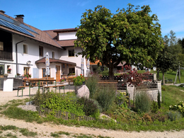
- Beautiful garden with a view to the "Höllengebirge" at the Almgasthof Schwarz
Starting point: Railway station Kammer-Schörfling
Destination: Railway station Kammer-Schörfling
further information:
- Flatly
- Board possible
details mountainbike
- Riding technique: medium
Spring till autumn!
Accessibility / arrival Accessibility / Arrival
By car:
From Salzburg via the A1 - Seewalchen exit
From Vienna/Linz via A1 - exit Schörfling or Seewalchen
From the west - Bad Ischl-Weißenbach-Steinbach-Weyregg-Schörfling
By train:
Coming from Salzburg or Linz/Vienna to Attnang-Puchheim or Vöcklabruck - continue with the Kammer Bahn to BH Kammer Schörfling.
Plane:
From Salzburg via the A1 - Seewalchen exit.
From Vienna/Linz via A1 - exit Schörfling or Seewalchen
Parking possibilities:
Accessibility / Arrival
By car:From Salzburg via the A1 - Seewalchen exit
From Vienna/Linz via A1 - exit Schörfling or Seewalchen
From the west - Bad Ischl-Weißenbach-Steinbach-Weyregg-Schörfling
By train:
Coming from Salzburg or Linz/Vienna to Attnang-Puchheim or Vöcklabruck - continue with the Kammer Bahn to BH Kammer Schörfling.
Plane:
From Salzburg via the A1 - Seewalchen exit.
From Vienna/Linz via A1 - exit Schörfling or Seewalchen
Parking possibilities:
- Train station Kammer Schörfling
- Freeway exit Seewalchen, opposite Eurospar in Seewalchen
- Parking space: 40
- All weather
- Suitable for groups
- Suitable for schools
- Suitable for teenagers
- Suitable for seniors
- Suitable for single travelers
- Suitable for friends
- Suitable for couples
- Spring
- Summer
- Autumn
- Early winter
Please get in touch for more information.
4864 Attersee am Attersee
Phone +43 7666 7719 - 0
Fax machine +43 7666 7719 - 19
E-Mail info.schoerfling@attersee.at
Web www.asc-attersee.at
Web attersee-attergau.salzkammergut.at
http://www.asc-attersee.at
https://attersee-attergau.salzkammergut.at
https://attersee-attergau.salzkammergut.at
You can also visit us on
Visit us on Facebook")
")
")
Interactive elevation profile
Create PDF
Tour-Details
Starting place: 4861 Schörfling am Attersee
Destination: 4861 Schörfling am Attersee
duration: 2h 33m
length: 27,5 km
Altitude difference (uphill): 847m
Altitude difference (downhill): 843m
Lowest point: 469m
Highest point: 866m
difficulty: medium
condition: medium
panoramic view: Some Views
Paths covering:
Asphalt, Gravel, Street, Other
powered by TOURDATA